This is part of a series of posts on about an old D&D campaign world called Malbeth.
Go to the original Ruins of Malbeth post.
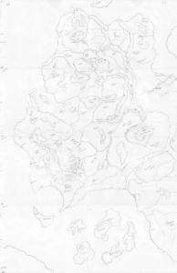
While Malbeth was an entire continent, the focus of my Malbeth-based setting was the Micel Kingdoms. As with the Malbeth map, the embedded map to the left is a scan of a pencil drawing I intended to eventually use to make a hex map with Hexographer hex map software.
Referencing the Micel Kingdoms map as needed, I hope this summary overview of the Mickel Kingdoms will make some sense. As I consider what I might want to take from Malbeth for future D&D campaigns, in future posts I’ll look at specific locations within the Micel Kingdoms. In this summary, I used all-caps to mark political entities such as a kingdom and italics to mark geographic entries such as a forest or mountain range.
Overview of the Micel Kingdoms
The campaign is set in the western half of continent of Malbeth in the lands in and adjacent to the Micelgeflowan River valley, one of the most continuously settled regions of Malbeth. The lands of the Micel Kingdoms, all of which once belonged to the MICEL EMPIRE, include a number of human, dwarven, gnomish, elvish, and halfling kingdoms, duchies, and communities along the Micelgeflowan River as well as the Cir Gap, the Western March, the Western Wilderness, parts of the Eastern March Forest, and a few islands in the Southern Sea.
The Micelgeflowan River valley is bordered by the Onnar and Fullangr Mountains to the north. Between them lies the Cir Gap, a broad cleft in the mountains that is dominated by the Cirelin Lake from which the Micelgeflowan River begins. The Cir Gap is also home to the high elf island kingdom of CIRTOL and the independent city-state of CIRLONN, which includes the mountain dwarf and rock gnome community of CIRABLE. North of the mountains and the Cir Gap is the Lambuletal, a tropical rain forest, and beyond that are the Hringtor Mountains and the Northern Sea. Along the northern shore of the Cirelin Lake is the sparsely populated LAMBULETAL FRONTIER, in which the only permanent settlement of note is the town of Cliff on the northern shore of Cirelin Lake.
South of the Onnar Mountains and west of the MICEL KINGDOMS is the Galarr Forest, a vast forest home to various goblin races. South of the Galarr Forest is the Bay of Nor, and below that is Norwood, another vast goblinoid-dominated forest. The far northwest of Norwood, along the southern mouth of the Bay of Nor is the high plateau known as the Ruins of Nor, home of the Lich-kings who ruled the EMPIRE OF NOR. Little is known of the Gallar Forest and Norwood, and even less is known of the Ruins of Nor, although tales and legends of its powerful artifacts and wondrous magics almost outnumber the tales and legends undead armies, dragons, deadly monsters, and all manner of nameless horrors that reside there.
Stretching south of Norwood along the coast to where the Western Sea meets the Southern Sea is the Western Wilderness, a sparsely populated frontier region dominated by the three coastal city-states of the WESTERN LEAGUE, the CITY OF NOR, VINDSVAL, and SYNDALA. Between the Western Wilderness and the Micelgeflowan valley is the Western March, a region also lightly populated except for the hill dwarf Kingdom of DVARLINN, unique in that it spans a number of underground dwarven holds along with a number of surface dwelling halfling and human farming communities, all connected by a network of fortified and surface roads.
The northeast region of the Micelgeflowan valley is bordered by the Southern Fullangr Mountains. The eastern region of the MICEL KINGDOMS south of the Southern Fullangr Mountains is the Eastern March Forest, home to the wood elves of THILCAMA and the forest gnomes of the EASTERN BURROWS. It is also home to the Gwathimlad, once the elvish homeland of ALCARINBAR, destroyed some 4,000 years ago in a cataclysmic event the elves call the Uplift.
Off the southern coast of the MICEL KINGDOMS are the halfling island KINGDOM OF KALBATHNOSS and the magocracy of OSSE.